- +91-11-4044-5999
- info@cdri.world
-
Copernicus Marg, New Delhi, INDIA
Urban cooling to mitigate heat exposure in Nepalese cities: Geo-spatial assessment of green roof, urban parks and wetlands
Dr Rocky Talchabhadel
Texas A&M AgriLife Research
Research problem: The Urban Heat Island (UHI) phenomenon affects over 70% of the world's population, compounding the effects of extreme heatwave events. Understanding UHI spatial heterogeneity for designing mitigation measures within a city is a complex and dynamic research problem that can strategically help many of the most vulnerable residents exposed to heat.
Innovation/novelty: Remote sensing of Earth Observations offers the benefits of long data archives, repeated observations, efficiency, and multiple spatiotemporal resolutions. In addition, these Earth Observations can augment ground-based, often unevenly distributed, air temperature sensors in understanding UHI spatial heterogeneity. Knowledge of factors that affect heterogeneity within a city can aid urban planning.
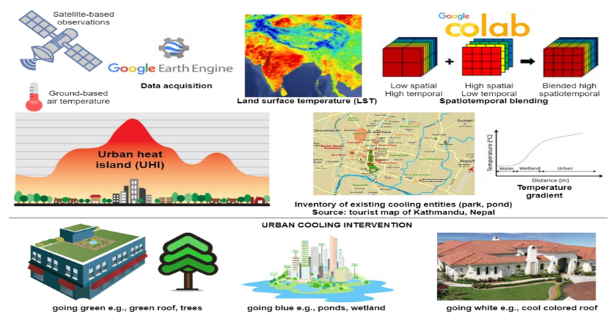
Proposed solution: The project identifies UHI spatial heterogeneity and assesses the performance of existing measures (e.g., urban parks, white/green roofs, and wetlands) to propose site-specific solutions for the study area. The project utilizes Earth Observations and available demographic and topological datasets to develop machine-learning models predicting UHI intensity.
Research Methodology: The project uses the GEE to analyze a long-term daily day- and nightLST (1 km MODIS) and high-resolution LST (30 m Landsat every 16 days). In addition, daily Planetscope data (3 m) will be used to explore land use and vegetation dynamics, employing several Machine Learning algorithms.
Practical application and implications: Impermeable urbanized surfaces store solar heat during the day and re-radiate from afternoon until late night, resulting in elevated temperature throughout. Hazardous heat has several adverse effects on human health and performance. The project focuses on understanding UHI spatial heterogeneity and aids in designing green solutions to mitigate UHI effects.
Assumptions: Various factors affect the UHI, including local and regional wind effects and spatial heterogeneity of green and blue areas. Cloud-free Earth Observations are generally available during heatwave episodes. During rainy days, the noises attributed to the cloud can be solved using interpolation techniques. Also, ground-based weather observations will be available.
Scope and limitations: With an uptake in rapid urban development, the UHI effects are becoming more pronounced. This project will concentrate on drivers of local UHI. EO and cloud computation are scalable methods for looking at great spatial detail. The current limits to atmospheric mechanisms and plans for on-ground validations.
 mainstreaming inclusion of persons with disabilities in disa.png)
