- +91-11-4044-5999
- info@cdri.world
-
Copernicus Marg, New Delhi, INDIA
Flood Disaster Resilient Hydraulic Design of Bridges Exposed to Climate Change
Prof. Rakesh Kumar
Department of Civil Engineering, Sharda School of Engineering & Technology, Sharda University Greater Noida (India)
Abstract: India is expanding its highway and railway networks for better connectivity and to give a boost to its infrastructure facilities and economy. For this purpose, the safe and optimal design of the bridges incorporating the impact of climate change is of primary importance. Inadequate hydraulic design of bridges leads to their failure whereas over-design results in excessive cost of construction.
A comparative study of the conventional approach in practice and the L-moments-based flood frequency analysis has been carried out, and the superiority of the L-moments over the conventional approach has been demonstrated. Based on the |Zidist|-statistic criteria as well as the L-moment ratio diagram, the Generalized Logistic distribution is selected as the suitable frequency distribution for the study area and design floods are estimated using this frequency distribution. The effect of climate change on the design floods and the resulting hydraulic variables of the river reach for the bridge site were simulated using the downscaled projections of climate scenarios and the defined increases in the design floods. Hydraulic modelling for the bridge site was carried out using the design floods for various scenarios to incorporate the impact of climate change in the hydraulic design of the bridge.
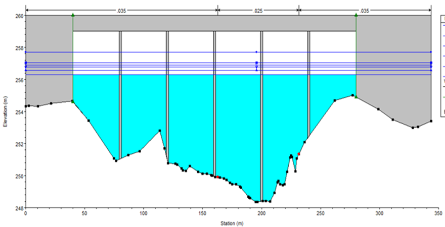
The floods of 50 and 100-year recurrence intervals computed by the L-moments method are 16.70 percent and 22.74 percent higher than the conventional method, respectively. The hydraulic modelling of the river reach of about 1.70 km is carried out using the HEC-RAS package for 24 river cross-sections obtained from the topographic survey. Based on the L-moments approach, the simulated water levels at the bridge are estimated to be 255.88 m and 256.40 m for 50-year and 100-year recurrence interval floods, respectively. Flow velocities are estimated to be 3.70 m/s and 3.90 m/s for 50-year and 100-year recurrence interval floods, respectively. The top width and hydraulic depth are also estimated by the hydraulic modelling approach. For 15 percent increase scenarios of 50 and 100-year recurrence intervals, water levels are estimated to be 256.31 m and 256.90 m. For the downscaled climatic projections, the water levels are estimated to be 253.48 m and 255.38 m for 2050 and 2100, respectively.
Taking the results of the various scenarios into consideration, the project authorities may make appropriate decisions for flood-resilient design and construction of the bridge. The methodology developed in the study will serve as a guideline/manual for the organizations involved in planning, designing and constructing bridges for their optimal hydraulic design. The departments involved in the construction of highways, railways and other bridges may apply this methodology for the construction of flood-resilient bridges exposed to climate change.
 in floating community space (fls) in the peruvian amazon.jpg)


 for infrastructures based on disaster.png)
